Fort Shevchenko and Bautino
Perched on the western tip of the Tub-Karagan Peninsula is the city of Fort Shevchenko and its satellite port town of Bautino. It’s the Mangystau
The Ryn, also known as the Naryn Sands, is Kazakhstan’s westernmost desert. It spans for over 350km between the Volga and Ural Rivers, and over 250km from the Caspian Sea’s north coast to the edge of the Pontic-Caspian Steppe.
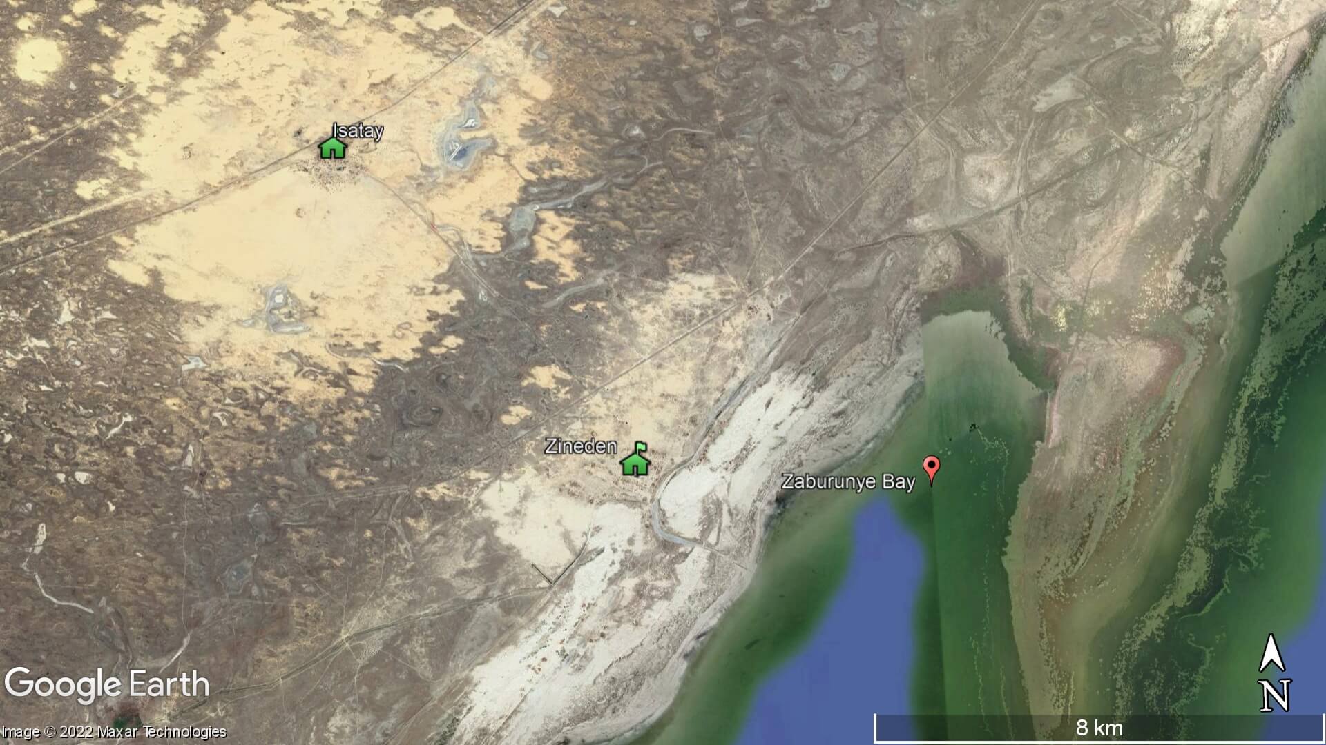
Extending 50km on either side of Isatay village is the Menteke Sands*, which forms the southernmost strip of the Ryn. Desertification is an issue in Isatay, as well as Zineden village, which is 8km to the south-east and overlooks Zaburunye Bay on the Caspian. A 2021 news report by Kazakhstan’s Khabar 24 TV channel, on the impact of desertification in the Atyrau Region, said that frequent sandstorms force residents to shut their doors and windows for up to eight months a year.
Isatay’s and Zineden’s residents blame the decreasing Caspian Sea levels, as sections of the seabed get exposed, dry out, and then blown inland. Undoubtedly, overgrazing has played a part, too. In 2001, researchers from the Finnish Meteorological Institute determined a dust storm around the Baltic Sea originated in the Ryn Desert.
Desertification is an issue elsewhere in the country. The Aral Sea and other regions in the west, such as Mangystau’s Senek village, are all facing similar problems. Fortunately, Kazakh authorities are working hard to combat the effects of desertification in the country by planting saxaul trees to limit erosion. So far, over 3,000 have been planted around Isatay and Zineden.
* There are several other areas of the desert with local names: Kosdaulet, Bozanay, Orda, Terektikum, Zhamankum, Zharshoshak, and Batpaysagyr.
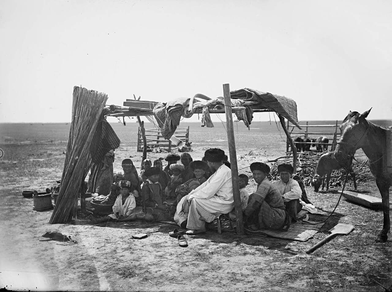
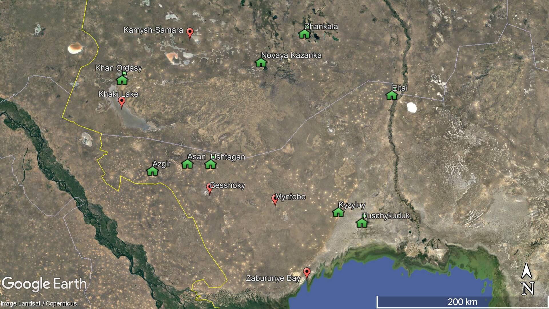
The Ryn Desert’s total population is approximately 120,000 people, with 75% based in the southern half (Isatay and Kurmangazy Districts). The Bokey Orda and Zhanakala Districts make up the northern half. Most settlements are in the desert’s outer perimeter, leaving much of the interior isolated.
The village of Kyzyluy, or Kyzyl Ui, meaning ‘Red House’ in Kazakh, is 80km north-east of Isatay village and one of the Ryn’s most well-known settlements. During the Soviet era, Kyzyluy acted as the administrative hub for collective farms in the Ryn. From the 1960s to 1980s, the USSR awarded medals to dozens of local shepherds and farm workers for their agricultural productivity. One example is Khatima Dayyrova, who managed the farms for two decades and received the Order of Lenin.
Today, Kyzyluy remains an important administrative hub for the Isatay District’s 80+ desert farms. In 2018, Muhambet Syekhov and Murat Bektenov, an oil worker born in the area, published The Red House is My Home. The book covers the history of the village and other settlements nearby, such as Tuschykuduk (fka Chapayevskoye) and Aybas.
Jerboa, hare and gophers inhabit the Ryn Desert. Around the settlements domesticated camels, sheep, goats and cows graze freely. Abundant fodder grass sustains the livestock, and common species include lyme grass (Leymus arenarius), sheep fescue (Festuca ovina), and bulbous bluegrass (Poa bulbosa). Other plants in the desert include aspen (Populus tremula), silver poplar (Populus alba), buckthorn (Rhamnus cathartica), wild olive (Elaeagnus angustifolia), and creeping willow (Salix fusca).
When walking around the desert, keep your eye out for Agriophyllum, which is a short, green and spindly plant. It’s locally known as kumarshyk and looks somewhat like thyme. Despite its humble appearance, this plant is a literal lifesaver. During periods of war and famine, people living in the Ryn would roast, bake and mill its seeds, and make porridge from it. This plant is so well-regarded locally that Bektonov published a book dedicated to it, called Kumarshyk, which details its historical usage. Atyrau scientists have also patented a drink combining kumarshyk with fermented camel’s milk.
In 2021, Kazakhstan’s government announced a plan to create the Bokeyorda Nature Reserve. It’s expected to cover a 6,570km2 area – roughly four times the size of Greater London – and aims to protect saiga from poachers.
The Ryn’s abundant groundwater, despite today’s arid landscape, has allowed settlements to thrive in the region for millennia, beginning with Stone Age hunter-gatherers. Later on, they developed into settled cultures centred on agriculture and animal husbandry. Examples of these groups, between the 4th to 2nd millennium BCE, include the Yamnaya, Catacomb, and the Srubnaya Cultures.
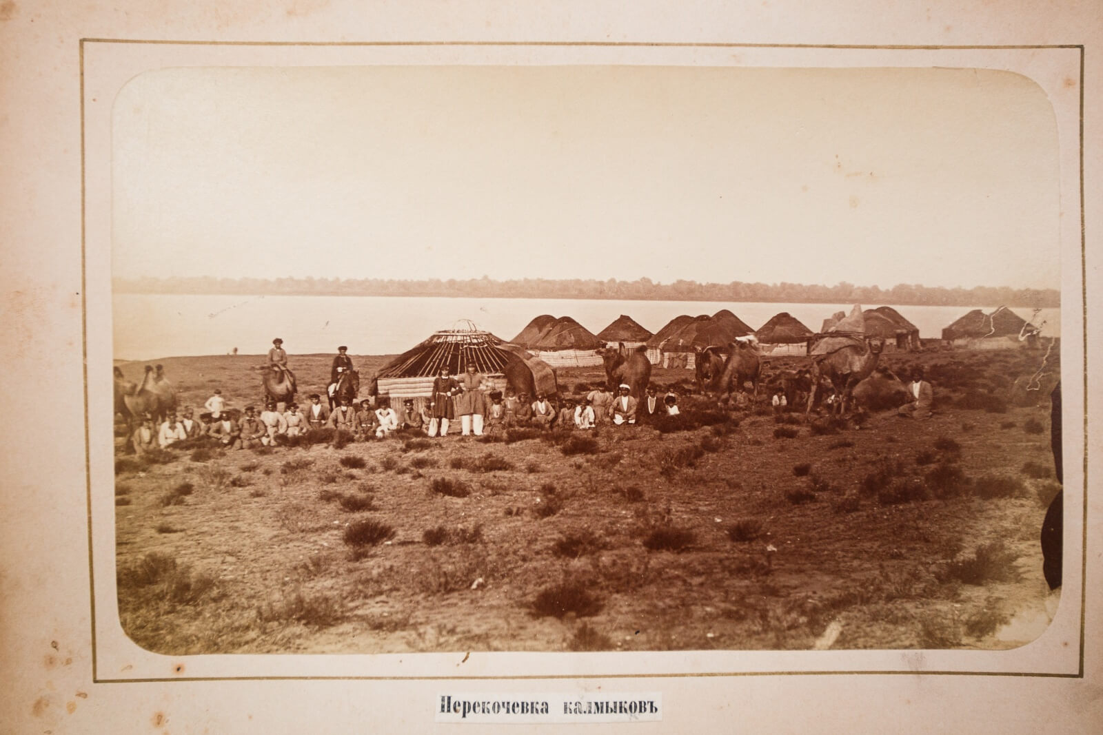
From the 1st millennium BCE to 5th century CE, Iranian language-speaking nomadic groups dominated the area. These were, in order of occurrence, the Scythians and Sakas, Sarmatians, and the Alans. Various semi-nomadic Turkic khanates succeeded them, run by the Göktürks, Onoğurs, and the Khazars (6th–10th century), the Cumans (10th–13th century), and the Mongol Golden Horde and the Great Horde (13th–16th centuries). After that came the Nogai Horde, who controlled large sections of western Kazakhstan and the Lower Volga, until the Kalmyk Khanate defeated them in the early–mid-17th century. During this period, Russian influence in the area increased.
The last khanate in Kazakhstan ended in the Ryn Desert, with the death of the Bukey Horde’s leader, Zhangir-Kerey Khan, in 1845. The village of Khan Ordasy, at the north-west rim of the Ryn, was its capital.
According to the Atyrau Regional Center for the Study of Historical and Cultural Heritage, there are approximately 1,000 sites of historical interest in the Ryn Desert. Russian archaeologist Ivan Sinitsyn and his team undertook the first comprehensive study of the region in the 1940s. On the shores of Soraydyn and Raim Lakes, which are at the northern edge of the Ryn, near Novaya Kazanka village, they discovered pottery and arrowheads from the Middle Stone Age to Copper Age*.
Since Sinitsyn’s pioneering work, a steady stream of Russian and Kazakh archaeologists have explored other parts of the Ryn. In 2020, a team from Kazakhstan’s Institute of Archaeology examined a section of the desert in Bokey Orda District and unearthed 50 new Stone Age sites. Most were concentrated around wells, the shores of salt lakes, and ancient river channels leading to the Caspian. One particularly abundant site for artefacts was the dune region south-east of Khan Ordasy village. There they discovered 150+ microblades and arrowheads made of quartzite sandstone and siliceous rock.
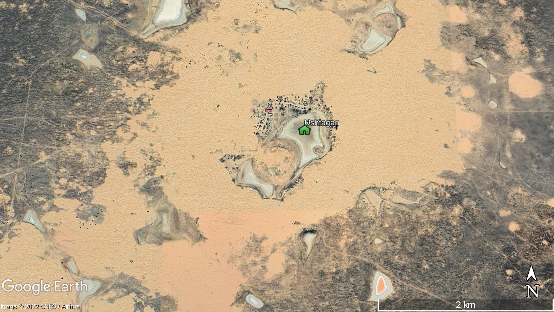
In the southern Ryn, a 2019 expedition by Atyrau’s local history museum recorded over 150 sites of historical, archaeological, or architectural interest in the Isatay and Kurmangazy Districts. The most significant were several dozen Early Iron Age burial mounds and fortresses near Asan, Ushtagan, Azgir, Myntobe, and Kyzyluy. Their extensive Naryn Sands archaeological exploration report includes coordinates for their finds.
* Ivan Sinitsyn’s archaeological expedition reports, for the western Kazakhstan and Lower Volga regions, are published in The Institute of Archaeology of the Russian Academy of Sciences’ journal (Институт археологии РАН): Edition 37, pp. 97–105; and Edition 45, pp. 62–73. A chapter overview for every Институт археологии РАН journal edition, since its establishment in 1939, is available here. Nina Morgunova’s paper on Copper to Early Bronze Age pottery in the region is a worth a read, too.
Besshoky (aka Bish-choho) is a salt dome, measuring 3.5km x 10km, located 30km east of the Russian border in a remote corner of the western Ryn. It rises to 30m in height and has several caves in sections of its gypsum caprock.
Speleologists from Astrakhan were the first to explore the area in 1987. A decade later, the Russian Geographical Society undertook four comprehensive research expeditions to the area and discovered Besshoky’s largest caves to date: Kenenbay, Mechta, and Kurmangazy. Of the three, only Kenenbay was previously known – to local herders – and the other two were new finds. Mechta is the largest, measuring 5m x 15m x 30m, and all feature beautiful gypsum stalactite formations. A monument to Kazakh musician Kurmangazy Sagyrbayuly (d. 1890s) stands 1km south-west of Kenenbay.
Access to Besshoky is via a dirt road near Kyzyldzhar’s N7 train station. Follow it north for 120km to reach Besshoky. From there, the road continues north-west for 280km+ to Khan Ordasy village.
Bokey Orda District is Kazakhstan’s westernmost district and shares a border with Russia’s Volga and Astrakhan Oblasts. Its landscape is a mix of Ryn Desert scrubland and dunes, and the Pontic-Caspian Steppe. The district’s most interesting sites are in and around Khan Ordasy village (aka Urda or Orda):
Zhangir-Kerey Khan’s mausoleum, 3km north-west of Khan Ordasy.
Bokey Orda Historical and Museum Complex at southern end of the village.
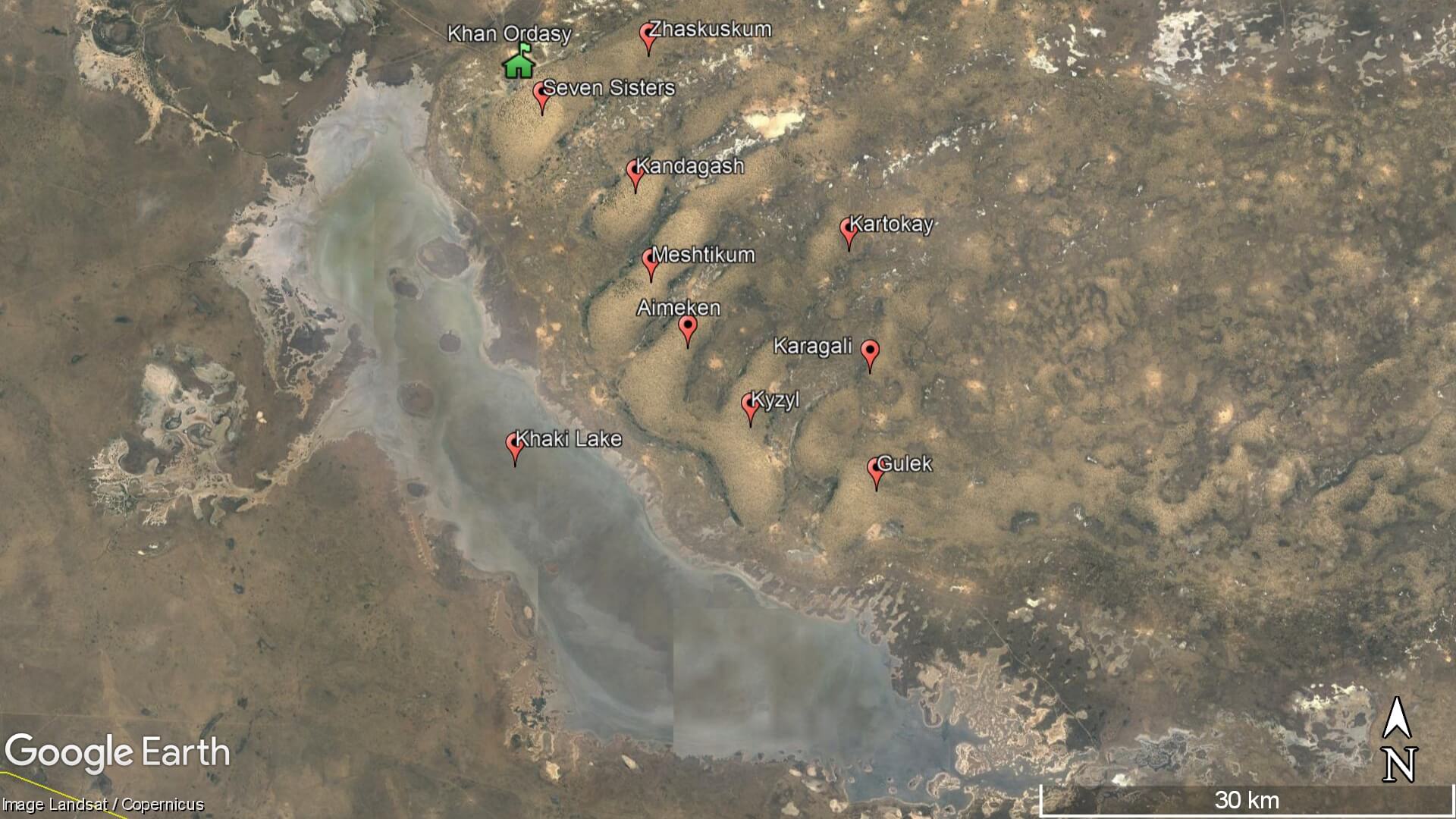
Salty Mud Lake (aka Khaki Lake), which is 8km south-west of Khan Ordasy and over 60km long and 10km wide.
The Seven Sisters and Zhaskuskum Sands, on the east side of Khan Ordasy, feature dense pine forests growing in their dunes and extend for over 40km along the east side of Khaki Lake. The other sand dunes (from north-west to south-east) are called Kandagash, Meshtikum, Aimeken, Kyzyl, Kartokay, Gulek and Karagali. These areas, together with Khaki Lake, provide a vital sanctuary for birds such as the oriole, goldfinch, hoopoe, and belladonna.
For a closer look at Khan Ordasy’s offerings – including the district’s administrative capital, Saykhin – watch Pearl of the Great Steppe’s documentary, as well as Kazakh filmmaker Alimbek Ulan’s Khan Ordasy village travelogue.
From Atyrau, you can drive to the south-east corner of the desert, around Kyzyluy, in a couple of hours. Isatay is a sub-four-hour drive from Atyrau. Along the A-27 road, which connects Atyrau and Isatay to the Russian border, there are numerous dirt roads leading into the desert’s interior. If you’re in the far western Ryn, make sure you don’t cross accidentally into Russia!
The A-28 road runs along the desert’s eastern edge, between Atyrau and Inderbor, with a multitude of turnoffs into the desert. On the outskirts of Eltai, which is across from Inderbor, there’s a well-used dirt road to Zhanakala town. From there, it’s a four-hour drive on the R-97 road to Khan Ordasy. The distance is over 200km, and the road divides the northern Ryn with the eastern Pontic-Caspian Steppe.
Atyrau Planeta offers quad biking trips in the desert, as well as jeep trips and camel rides, starting from Isatay village.
Zineden Village (Зинеден): 46.7426, 50.1415
Isatay Village (İsatai/Исатай): 46.7986, 50.0677
Zaburunye Bay (Zaburunye şyğanağy/залива Забурунье): 46.7392, 50.2125
Kyzyluy (Qyzylüi/Кызылуй): 47.3778, 50.7187
Novaya Kazanka Village (Jañaqazan/Жанаказан): 48.9323, 49.6046
Asan Village (Асан): 47.9084, 48.4426
Ushtagan Village (Üştağan/Уштаган): 47.9029, 48.7972
Azgir Village (Azğyr/Азгир): 47.8375, 47.9079
Myntobe Settlement (Myñtöbe/Мынтобе): 47.5000, 49.7669
Eltai Village (İeltai/Елтай): 48.5499, 51.6165
Zhanakala Town (Jañaqala/Жанакала): 49.2149, 50.2972
Tuschykuduk Town (Tūshchyqūdyq/Тушчикудык): 47.2585, 51.0689
Aybas Village (Aibas/Айбас): 47.2553, 51.0775
Khan Ordasy Village (Han Ordasy/Хан Ордасы): 48.7692, 47.4314
Besshoky (Beşoqy/Бесшокы): 47.6297, 48.7805
Dirt Road to Besshoky Near Kyzyldzhar’s N7 Train Station: 46.6868, 49.3475
Kenenbay Cave (Kenenbay üñgiri): 47.6492, 48.8044
Kurmangazy Sagyrbayuly Monument: 47.6415, 48.7964
Zhangir-Kerey Khan’s Mausoleum: 48.7938, 47.4069
Bokey Orda Historical and Museum Complex: 48.7680, 47.4258
Khaki Lake (Урочище Соленые Грязи “Хаки”): 48.5175, 47.4292
Seven Sisters Sands (Jetı Apaly-Sıñlılerdıñ Qūmdary/Пески Семь Сестер): 48.7452, 47.4543
Zhaskuskum (Jaskuskum/Жаскускум): 48.7836, 47.5588
Kandagash (Qandağaş/Кандагаш): 48.6947, 47.5463
Meshtikum (Meşıtqūm/Мешиткум): 48.6372, 47.5619
Aimeken (Aimeken/Аймекен): 48.5944, 47.5980
Kyzyl (Qyzyl/Кызыл): 48.5436, 47.6597
Kartokay (Qartoqai/Картокай): 48.6574, 47.7561
Gulek (Gülek/Гулек): 48.5019, 47.7830
Karagali (Qarağali/Карагали): 48.5783, 47.7766
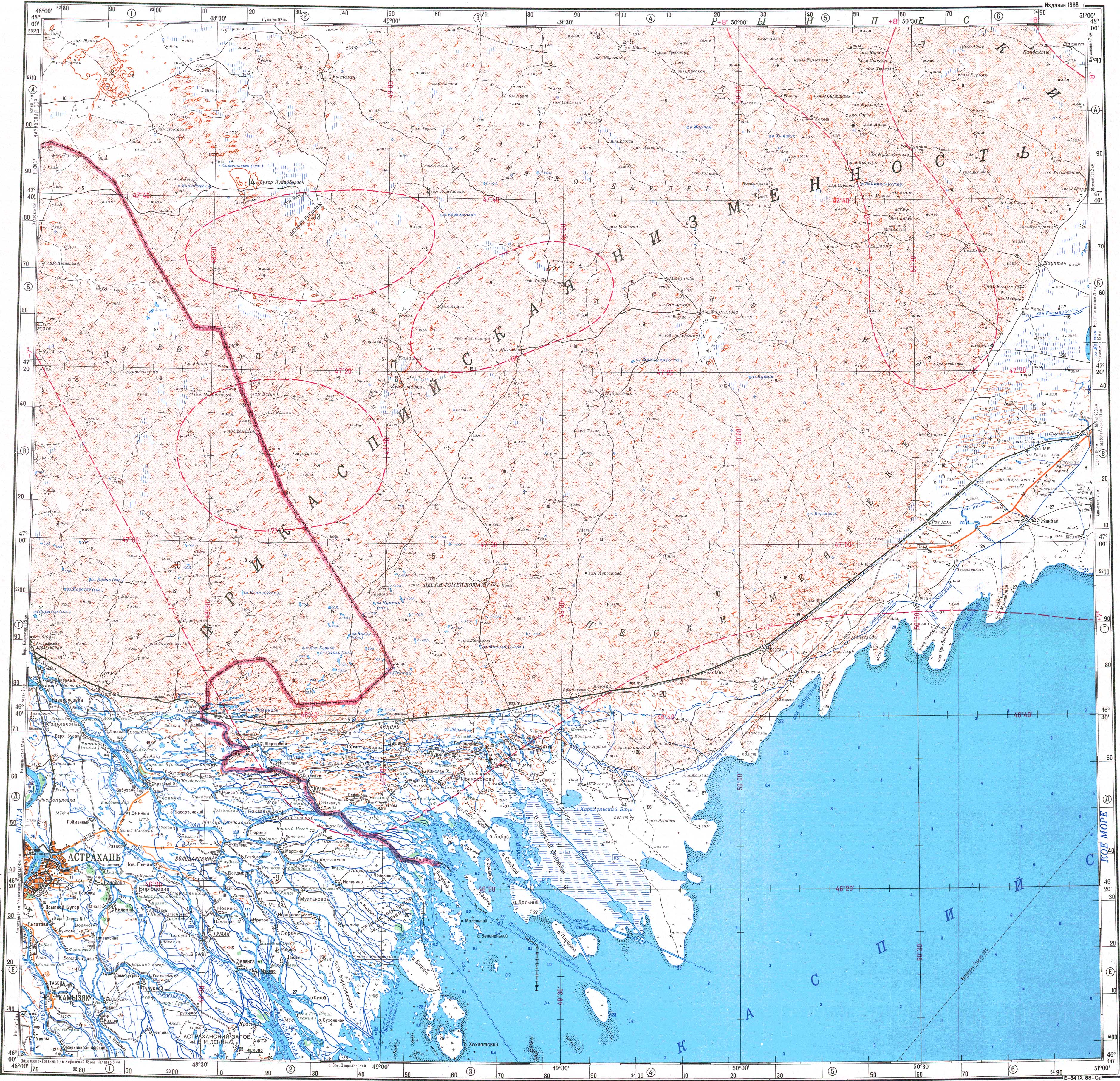
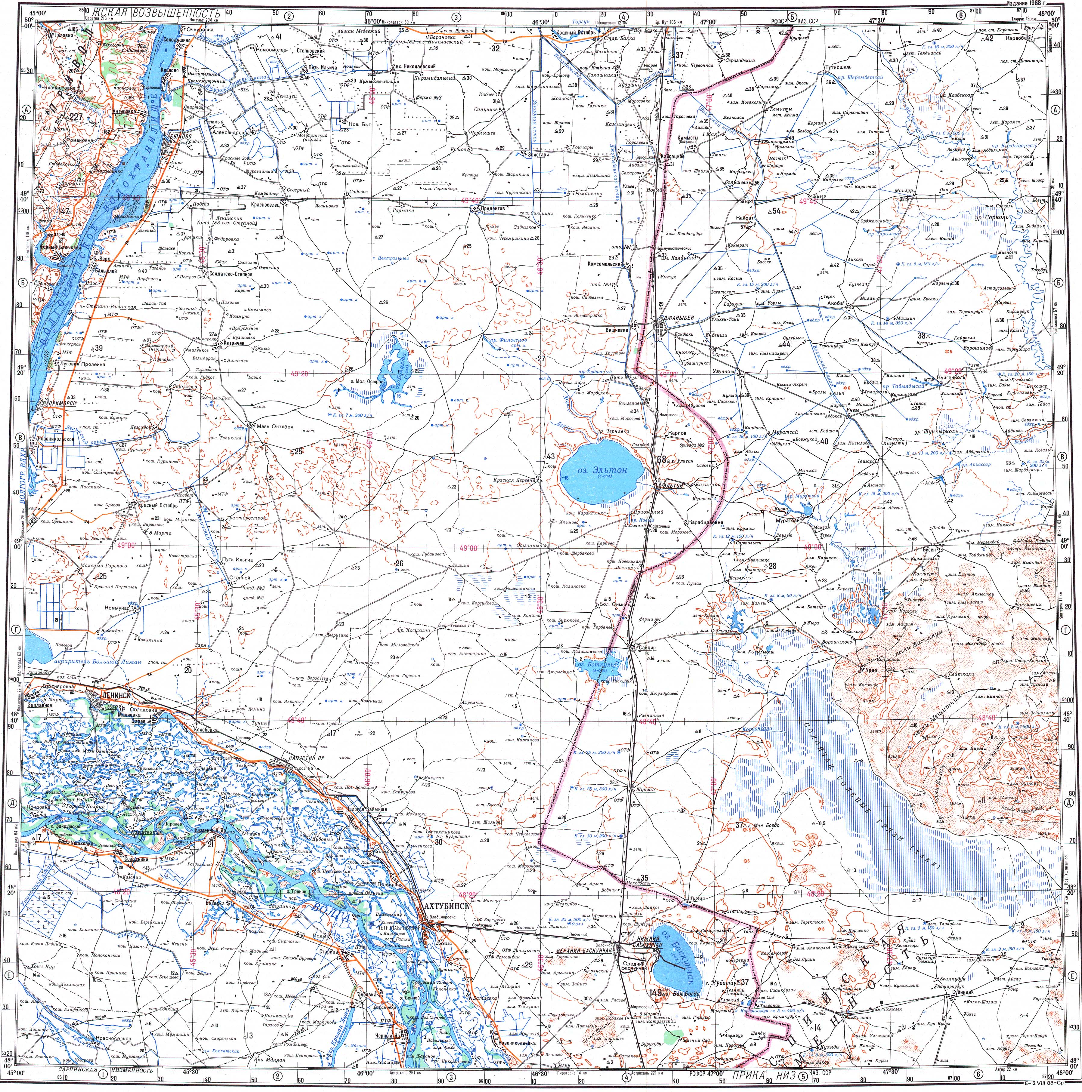
1:500k Soviet map of the Ryn Desert‘s central and southern part, which is marked as “Прикаспийская низменность” meaning ‘Precaspian Lowland’. The bottom-right quarter shows the Menteke Sands (‘Пески Ментеке’), which is near to the Caspian Sea.
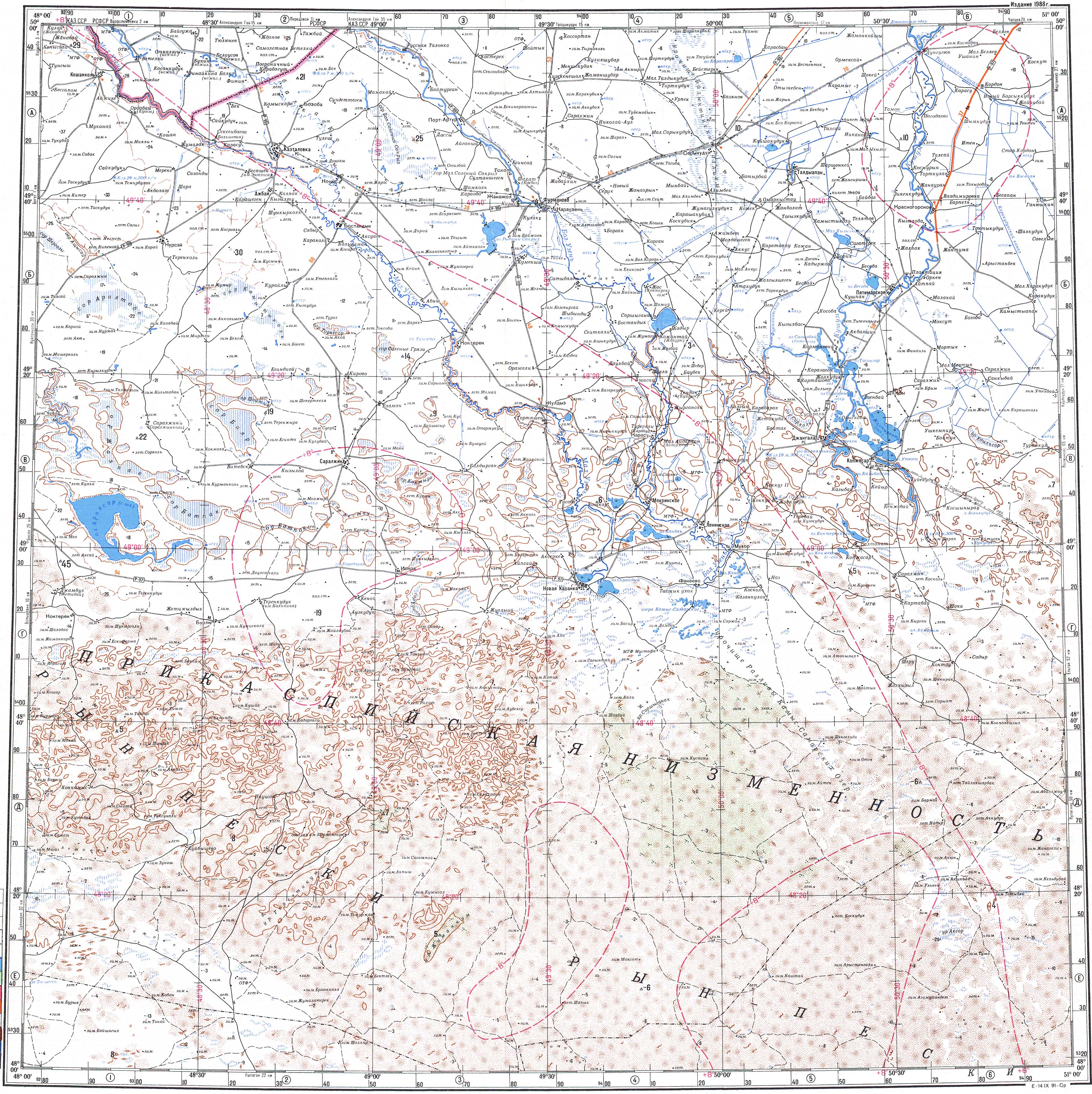
1:500k Soviet map of the northern Ryn Desert, with Kamysh-Samara pictured in the middle; 1:500k Soviet maps of the far eastern part (leading to the Ural River); and the far western reaches (near to Russia’s border).
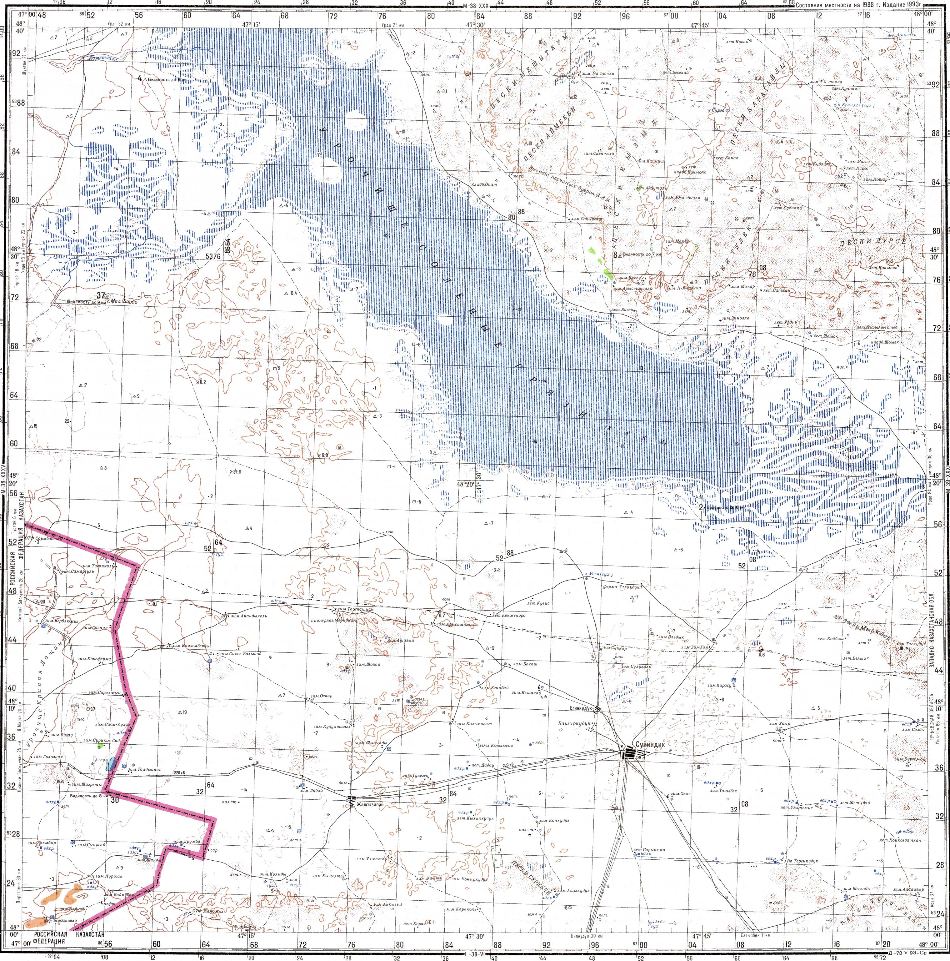
1:200k Soviet map of Khan Ordasy, shown in the bottom-left quarter as “Урда”, and a map of Khaki Lake and Khan Ordasy’s southern sand dunes.
Qazaq TV’s English-language Bukey Horde documentary.
Official website of The Institute of Archaeology of the Russian Academy of Sciences.
Kazakh blogger Temirlan Mukashev’s video documenting his trip to the Ryn Desert’s north-east corner, in Zhanakala District, which includes extensive footage of the dune systems.
Drone video of the sand dunes in Isatay District and the nearby north Caspian coastline.
Ural Week video showing the dunes and nature near Novaya Kazanka.
Video of dunes in Aybas, lightly dusted in snow.
Photos from the Russian Geographical Society’s 2019 expedition to Besshoky and an official report in the Astrakhan Local History Bulletin (pp. 15–18, Issue VIII, 2019), which is published by the Astrakhan branch of the Russian Geographical Society.
Aqparat’s 2019 news report showing the challenging, and ultra-muddy, road conditions in Bokey Orda District.
Extensive collection of short and well-researched articles on the deserts of the Caspian Sea, including their geography, vegetation, soil profile, and history.
Bokey Orda District vlogger and agriculturalist Sayan Baetov’s YouTube channel offers insight into rural life and the landscape.
Photos by NASA Earth Observatory of Isatay’s desertification in winter.
Perched on the western tip of the Tub-Karagan Peninsula is the city of Fort Shevchenko and its satellite port town of Bautino. It’s the Mangystau
Aktobe is on the western end of the Kazakh Steppe, less than 100km from the Russian border. As the capital city of the Aktobe Region,

Tucked away inland of Sarytash Bay is the 10th-century Shakpak Ata, one of Mangystau’s most well-known historical-religious sites. Tauchik, a small village, is the nearest