
Aktau
Aktau serves as a perfect starting point for journeys into the Ustyurt and the broader Mangystau Region. Its strategic location on the Caspian Sea, coupled
Atyrau, a bustling city less than 15km from the Caspian Sea’s north coast, sits amid the stark beauty of the Caspian Lowland. Surrounded by sandy deserts, arid scrubland, salt marshes, and rural villages, the riverside metropolis offers a wealth of sights that extend far beyond the city limits.
The origins of Atyrau city began in the 1550s after Tsar Ivan the Terrible’s soldiers overthrew the Astrakhan and Kazan Khanates, which resided west and north of western Kazakhstan, respectively. This granted them easier access to the Nogai Horde, who controlled much of the Caspian Lowland and the eastern Pontic-Caspian Steppe.
In 1640, fishing merchant Guriy Nazarov and his sons, from an esteemed trading family from Yaroslavl, Russia, were the first to settle in the area. They agreed to pay land tax to the Nogai, whose capital city, Saraishyk, lay 50km to the north and erected a wooden wall around their burgeoning hamlet to protect them from roaming Kalmyk and Turkmen bandits. The settlement was known by several names initially: Ust-Yaitsk, meaning ‘Mouth of the Yaik’, and Nizhne-Yaitsky for ‘Lower Yaik’, both reflecting its location along the Yaik River, known today as the Ural River. Uyshik was another name, derived from uchug—a Russian word for wooden fishing weirs, which Nazarov laid across sections of the river.
In just a few years, the settlement’s economy strengthened, and they stopped paying taxes to the Nogai. The site was also upgraded with a stone fortress and featured a single gate on the east side leading to the river, along with a lighthouse, watchtower and guard ship positioned nearby. This newfound prosperity, however, sparked discontent among the Cossacks living in the upper reaches of the Ural River, such as around Oral. They argued the weirs were adversely affecting fish populations in other parts of the river. As a result, several Cossack leaders launched attacks to plunder the settlement and take over the weirs: Ivan Kondyrov (1649), Parshin (1660), and Vaska Kasymov (1667). A month after Kasymov, Cossack leader Stepan ‘Stenka’ Razin and his detachment overtook the town and briefly turned it into a base for his rebellion against Tsarist Russia.nd his rebel band maintained control of the town until March 1668, enduring several weeks of conflict with archers dispatched by the Tsarist government. A significant number of these archers declined to engage Razin, while those who confronted him were defeated or drowned in the river. Ultimately, Razin and his forces had to flee, breaking through an encirclement of additional archers and fleeing across the Caspian Sea to Persia. The remainder of the 17th century and into the early 18th century saw repeated attacks on the weirs and further rebellions by the Cossacks. In 1717, Alexander Bekovich-Cherkassky passed through the town on his mission to find gold in the Aral Sea Basin.
In 1734, with Empress Anna of Russia now in power, Ust-Yaitsk was granted city status and renamed to Guriyev*. Notable events from the 1740s to 1760s include: The opening of a bi-annual trade yard for travelling merchants on the Ural’s left bank (1744); Junior Zhuz leader Eset Batyr, from the neighbouring Aktobe Region, setting up a trading site comprising 3,000 tents (1748); the Astrakhan Governate, which ran the city, entrusting the Cossacks to manage and protect the Ural’s fisheries (1752); transfer of jurisdiction from Astrakhan to the Orenburg Governate (1753); and a visit by Prussian naturalist Peter Simon Pallas on his expedition for the Russian Academy of Sciences (1769).
In the 1810s, the founding fort was demolished, after its strategic importance diminished. Since then, western Kazakhstan has remained stable, aside from a handful of Kazakh-led, anti-Russian colonisation rebellions in the 19th- and early-20th centuries. These include the last khan of the Kazakh Khanate, Kenesary Kasymuly, and his 1837–1847 fight to reinstate independence to the country’s provinces; the 1870 Mangystau-based Adayev Uprising challenging the Russian Empire’s claim of Kazakh land as state property; and the 1836–1837 rebellion led by Makhambet Utemisov and Isatay Taymanuly*, aimed at ousting Zhangir-Kerey Khan and his men from their rule over the Bukey Horde, which was an autonomous Kazakh khanate, existing from 1801 to 1845, between the Volga and Ural Rivers.
Commercial oil prospecting began in the Atyrau Region in the 1890s, more than half a century before Mangystau’s. Although local Kazakhs long knew of the existence of oil in the region, as they used it to treat skin conditions. In 1899, in the Karachungul Basin, located 120km north-east of Atyrau in the Makat District, Lehman and Co. achieved a significant milestone in Kazakhstan’s oil industry with the production of the country’s first barrel of oil. Following this discovery, international interest surged, with British, French, German, and Swiss companies tapping their own wells. The Nobel family, renowned for their oil ventures in Azerbaijan and inventor Alfred Nobel, had their own operations as well. Camels, carrying the oil inside of animal skins, were used to transfer the oil to the Caspian coast, and from there it was refined and shipped elsewhere.
* Alternative spellings: Guriev and Guryev; Otemisuly/Utemisuly and Tay-/Taimanov.
By 1930, there were over 300 oil fields in the Caspian Lowland, most of which were sited on naturally occurring shallow oil pools easily identified by surface mapping. Production ramped up during WWII, as oil was required for bomb making, machine and weaponry lubricant, transportation fuel, synthetic rubber, and more. Changes to seismic and geological mapping in the 1920s, introducing rotary drilling, more qualified technicians, building more pipelines, and constructing a steam electricity station in Kamyskul all helped the Soviets to meet the demand.
In 1992, then President Nursultan Nazarbayev decreed to rename Guriyev to Atyrau. As a word, ‘atyrau’ is a regional term to describe the landscape of the north-east Caspian’s coastal river mouths, in particular its reed beds, islands, and tree-like deltas.
Today, Atyrau is home to over 300,000 people, with two oilfields playing an important part in the city’s economy; the Tengiz, on the north-east Caspian coast, and the offshore Kashagan facility. Ship repair yards, a petrochemical plant, fish cannery, and construction industries bolster the city’s economy too.

As the only major urban settlement in the area, Atyrau is the place to head to if you’re looking to stock up on supplies before venturing elsewhere in the Caspian Lowland. For a closer look at the city’s scenery and daily life, check out this Atyrau tourism video.
Atyrau’s Regional Museum of History and Local Lore is on the corner of Azattyq Avenue and Bauyrzhan Momyshuly Street. When it opened in 1940, it had 300 items on display. Today there are over 60,000 pieces in their collection, if we include the nine departments it oversees, some of which are in districts outside of the city. It has display rooms covering the Atyrau Region’s ethnographic history, archaeology, WWII, Soviet era, and much more. There are also jewellery, textile, musical instrument, and clothing collections.
Across the road, on 11 Azattyq Avenue, is the Atyrau Regional Art Museum, boasting 1,200+ exhibits spread across eight halls. One highlight is a collection of portrait paintings by Shaimardan Sariev.
If you’re a dinosaur fanatic, head to the Museum of Palaeontology on Mukhtar Auezov Avenue, 2.5km south-east of the history and art museums. Inside are the remains of wooly rhinoceroses, mammoths, and aurochs, which are ancestors of modern domestic cattle that roamed Eurasia and North Africa for 2 million years before going extinct in the 17th century. Scientists, however, are looking to revive the species and reintroduce them into Europe, believing they might positively affect the region’s biodiversity and prevent habitat loss.

Less than one kilometre east of the local history museum is the Makhambet Utemisov Kazakh Drama Theatre, on 8 Abai Street. Opened in 1938, it’s one of the oldest theatres in Kazakhstan and holds a prominent place in the cultural life of Atyrau and the greater Atyrau Region. A group of talented young Kazakhs who completed a one-year drama school established it. One of their debut performances was Mukhtar Auezov’s Tungi Saryn (meaning ‘night time’)—a play set in the early 20th century and revolving around the life of Kazakh people during that period, touching upon social issues, love, and family relationships.
The theatre’s repertoire expanded over time to include both classical and modern plays. Although WWII interrupted the troupe’s creative growth, the women’s team continued its work. After the war, the theatre thrived with a growing troupe and an increasing number of theatre-goers. In 1975, it moved to a new building in the city centre, where it stands today. The theatre underwent major renovations in 2006, updating much of its equipment.
Built after WWII as a residential area for industrial workers and their families, Zhilgorodok is a historic neighbourhood in Atyrau. Situated on the east bank of the river, its highlights include the palatial Kurmangazy Palace of Culture on Mukhtar Auezov Avenue, and a collection of statues of Lenin, Bolshevik revolutionary Sergei Kirov, and Red Army commander Vasily Chapaev running alongside Nurtas Ondasynov Street. The suburb also has the impressive half-kilometre-long Retro Park and a small, sandy beach beside it. For a bird’s-eye look, check out Teobaldo Marzulli’s aerial video of Zhilgorodok, which includes the park, theatre and more.
From Zhilgorodok, which is on the ‘Asian’ side of the river, you can cross over the footbridge into Europe. Once there, follow Zeynolla Ghumarov Street for half a kilometre and turn right at Admiral Vladimirskii Street, and walk one kilometre along it to reach Satpayeva Street.
Starting from Satpayeva’s western end, there are numerous sights along this 2.5km street, which takes you back towards the main bridge near the art and history museums. Highlights include the Folk Music Academy’s statue of accomplished dombra-player Dina Nurpeisova, and the Imangali Mosque, near the corner of Isatay Taimanov Avenue.
The mosque covers a 10,000-square-metre area and is built in a classic Islamic architectural style, with a dome-topped central hall and several minarets on each corner. East of it is Makhambet and Isatay Square, opened in the mid-1990s to celebrate the 200th birth anniversary of Makhambet Utemisov, a national poet and leader of the national liberation movement. The centrepiece of the square is the Makhambet-Isatay Monument, featuring a five-metre-tall bronze sculpture of horse riders mounted on a granite pedestal.
At the east end of Satpayeva Street, near the main bridge, is a statue of Beybarys who was a Kipchak – a Turkic nomadic culture from the Eurasian Steppe. He became the commander of the Mamluk Sultanate, which covered Egypt, the Levant, and parts of the western Arabian Peninsula from 1250 to 1517.
For military history aficionados, head to Victory Park, which is 600m south of the bridge connecting Zhilgorodok. The park’s centrepiece is the Eternal Flame, surrounded by a granite wall depicting scenes from WWII. There’s also a small area honouring soldiers who served during the Afghan-Soviet war, as well as old military transport on display.

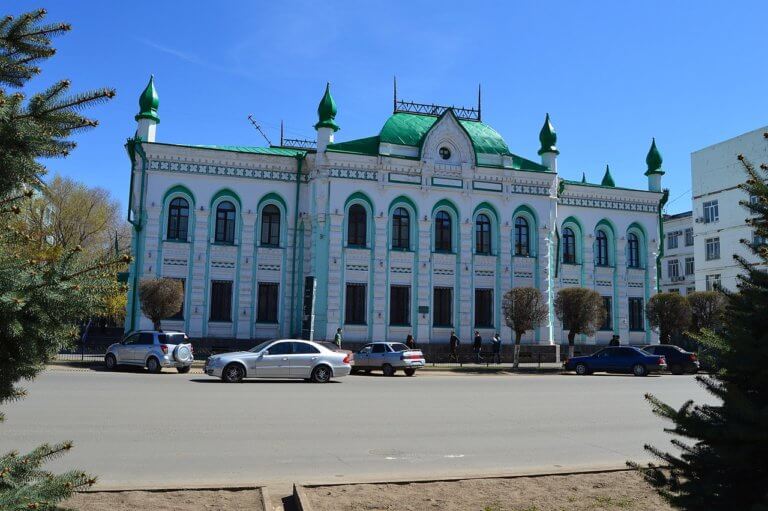
Less than one kilometre north of Makhambet and Isatay Square is the Uspensky Cathedral, on 4 Isatay Taymanov Avenue. Also known as the Holy Dormition Cathedral, it was built in 1888 with funding from merchant-fisherman Fyodor Tudakov and other local businesspeople. In 1924, like many other Orthodox churches, it was closed under the Soviet Union’s anti-religious policies and plundered. However, some parishioners saved and hid the surviving items, and converted the building into a stable and warehouse.
In the 1950s, the cathedral re-opened and the parishioners refurbished it. By the end of the 20th century, the building was in disrepair. In 2000, city and regional authorities initiated large-scale restoration, replacing the roof, painting the domes and brickwork, and renovating the bell tower. Today, it houses the relics of revered saints, such as Tikhon of Moscow (d. 1925), and valuable depictions of icons like the Theotokos of Tikhvin.
The Akzhaik Biosphere Reserve covers 3,400km2 of the Ural River Delta, with roughly one-third of the area protected from development and human interference. Its wetlands gained Ramsar site status in 2009 and attract 240+ migratory bird species, including the Dalmatian pelican, spoonbill, bustard, white-fronted goose and Siberian crane. The semi-desert surrounding the reserve hosts rare species too, such as the steppe eagle, grey lark, and demoiselle crane. In terms of mammals, there are marbled polecats, European mink, Russian desman, among others.
Currently, there’s no established tourism infrastructure in the delta, although it may be possible to arrange a boat trip if you head to Damba village, 20km south of Atyrau. Failing that, try Peshnoy settlement, located 10km to the south-east and the last habitation before the Caspian—bear in mind, you’ll need a 4WD to go beyond Damba as the track is prone to flooding. Check out this brief report by Khabar TV showing footage of an Ural River Delta boat ride, and the area’s rich birdlife, sandy shores, and dense reed thickets.
An hour’s drive north of Atyrau is Saraishyk, a settlement built on the Ural River’s west bank in the 10th–11th century. During the Silk Road era, it was an important trading hub and city for the 13th–14th century Golden Horde – originating from the Mongol Empire – until Timur’s forces attacked and ruined it in 1395. In the 15th century, it was rebuilt and inhabited by the Nogai Horde and later the Kazakh Khanate. It’s said the name means either ‘yellow crescent’ or ‘small palace’.
In the 14th century, Arab traveller Ibn Battuta visited Saraishyk on his way to the Aral Sea’s Khwarezm region, as part of a 120,000km odyssey across Asia, the Middle East, and north and east Africa. He originally set out on a pilgrimage to Mecca in the 1320s, but extended his travels for nearly three more decades, visiting 44 modern countries. Along the way, he narrowly avoided being beheaded, married three women, survived a near-drowning at sea on his way to Crimea, dodged bandits, and survived an ambush by Hindu cavalrymen. In his travelogue (rihla), he describes seeing camel-drawn carts crossing the Caspian Lowland and a bridge “like the bridge of Baghdad” over the “Ulu Su” (Ural River).
Local legends suggest the Golden Horde redeveloped Saraishyk to resemble Sarai Batu, which was founded in the 1250s by Mongol leader Batu Khan, who was Genghis Khan’s grandson, and had a population of roughly 70,000 people. It was situated approximately 120km north of present-day Astrakhan, Russia, on the Lower Volga River, and served as the capital of the Golden Horde.
You can find out more about the riverside archaeological site and the nearby museum via Saraishyk’s website.
Drive 30 minutes north from Saraishyk to reach Makhambet town, in the eponymous district, named after Kazakh rebellion leader Makhambet Utemisov. To learn more about the man and his battle against the Bukey Horde, visit the Makhambet District Historical and Local Lore Museum in the main square. It’s open from 9am to 6pm, Monday to Friday. There are various displays about the district’s local figureheads, artefacts from Saraishyk, and old weapons.
Eight kilometres east of the town, across the Ural River, is Altyn Necropolis, which dates back to the 19th and 20th centuries. Smaller than other similar complexes in the region, it contains around 200 tombstones from different time periods. The necropolis features rare examples of stone-cutting art influenced by Volga Tatar culture.
According to local legends, the necropolis gets its name from the Berish-Sebek clan leader’s eldest daughter, who was tragically murdered by robbers. Although he had eight other daughters, Altyn was his favourite, and her resting place later became the centre of the necropolis. The site was placed under state protection in 1990 and is now a popular pilgrimage destination.
From Makhambet, Inder Lake is less than a two-hour drive north of the town. Atyrau filmmaker Tilek Askarov has an informative video about Inder Lake and the district’s highlights, with aerial footage.
The Kazakh portion of the Caspian Lowland, between the Ural River and Russian border, is an intriguing part of the Atyrau Region. It’s slightly smaller than Latvia and rarely visited. At its southern end are the Menteke Sands, which extend for 50km+ either side of Isatay village along the Astrakhan–Atyrau road and join the Ryn Desert on the north side. From there, the Ryn extends for a couple of hundred kilometres north to Khan Ordasy village, also known as Orda. Contact Atyrau Planeta for camel, jeep, or quad biking trips into the desert, starting in Atyrau and entering the Menteke Sands at Isatay.
If you’re looking for a somewhat different shopping experience, head to the Tuma Livestock Market on Bigeldinov Street. On holidays and special occasions, such as Qurban Ait, it’s a tradition for people around Atyrau to bring their sheep to the market for slaughter. Afterward, the attendees divide the meat into three parts, sharing it first with those in need, then neighbours and relatives, and the remainder is used to cook a celebratory meal. For regular shopping, head to the Atyrau Shopping Mall on 17 Satpayeva Street.
As the crow flies, Atyrau is 1,400km from either Moscow or Astana, and its closest cities, Oral and Astrakhan, are a 6–9-hours’ drive away. Considering the Arctic Norwegian town of Kirkenes is dubbed as ‘Europe’s most isolated town’, yet it’s a mere four-hour drive to the Russian city of Murmansk, and Atyrau’s geographically part of the European continent, we think Atyrau could be the remotest city in both Central Asia and Europe! Despite the city’s out-of-the-way location, Atyrau’s still surprisingly accessible.
Here’s a summary of the transportation options available.

There are regular buses to Kulsary and Oral from the bus depot directly in front of the railway station, on Musa Baymukhanov Street. If you need a lift to or from the station, Atyrau newspaper Ak Zhaiyk has a directory of Atyrau taxi services. Rides cost a couple of dollars to the city centre. Alternatively, bus number 14 runs between the city centre and railway/bus station.
It’s a 10-minute drive from the train station to the city centre. As a guideline, there’s a daily departure to Aktobe (16 hours), Mangyshlak (22 hours), and Almaty (40 hours), plus several per day to Oral (25–45+ hours) and Astana (40–48+ hours). Whatever route you take, there are countless places to hop off, from isolated steppe towns to big cities, along with trains heading to Astrakhan (12 hours), Tashkent (40–48+ hours) and beyond.
Atyrau’s airport lies less than 10km west of the city. SCAT Airlines operates daily direct flights to Almaty and Astana, taking less than three hours. Bi-weekly ones to Taraz, near the Kyrgyzstan border, and Istanbul are available too. Air Astana offers direct flights to Aktobe and Aktau (1 hour), as well as Almaty, Astana, Shymkent, and international destinations like Kutaisi, Istanbul, Sharm el-Sheikh, and Amsterdam. Buses and taxis are available to and from the airport.
Aktau serves as a perfect starting point for journeys into the Ustyurt and the broader Mangystau Region. Its strategic location on the Caspian Sea, coupled

Fifteen kilometres north-west of Shetpe town is Ayrakty-Shomanai, or as 19th-century Ukrainian artist-poet Taras Shevchenko preferred to call it during his stay in Mangystau, ‘The
Oral is a lively city nestled on the banks of the Ural River. Like Atyrau city, it marks the geographical divide between Europe and Asia.