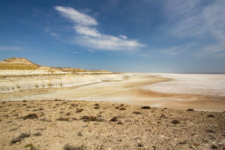
Mugodzhar Hills

The Mugodzhar Hills form the southernmost part of the Ural Mountains. The range starts near the Kazakh-Russian border and extends south for 200km+ through the Aktobe Region, forming a geographical boundary between the Caspian Sea and Turgay River drainage basins. Mount Bolshoy Boktybay (657m) is the highest point.

Debate surrounds the exact point where the hills, and by extension the 2,500-kilometre-long Ural Mountains, end. Among Russian researchers, one team argues the Urals finish at the southern end of Shoshkakol Ridge (405m), next to the Shagyray Plateau, which separates the Aral Sea and Caspian Sea Basins. Another believes the endpoint is Zhamantau (372m), located over 80km north-east of Shoshkakol Ridge, because from here the Uralian orogenic belt, primarily composed of crystalline rocks, dips below the Earth’s surface, giving way to the Ustyurt Plateau’s sandstone, chalk, and marl rocks.

Note: Variant spellings for the Mugodzhar include Mugojar, Mugodjar, Mugodjary, and Mughalzhar. Also, Zhamantau is sometimes spelt as Yaman-Tau and Yamantau, which is also the name of another mountain in the Urals, in Beloretsky District, Bashkortostan, Russia.

Satellite view showing the full length of the Mugodzhar Hills
Map Data: Google, © 2022 Landsat / Copernicus

Mugodzhar Hills Rivers

The Mugodzhar Hills are up to 20km wide and its slopes give rise to several major rivers. The Emba River is the longest. From its source, in a small valley beside Mount Kenkus (557m), it flows for more than 700km through the Emba Plateau to the Caspian Sea. Along the way, it passes by an 80-kilometre-wide expanse of sand dunes that form the Kokzhide-Kumzhargan Nature Reserve.

Thirty kilometres north-west of the Emba’s source, the Shiyli and Terisbutak Rivers meet and form the Or River, which flows 332km north to join the Ural River.

In the north-east foothills, beside the Russian border and 5km south-east of Aktastykul, the Irgiz River begins its 590km+ journey south through the Turgay Plateau wilderness and then empties into the Shalkarteniz salt marsh, which was connected to the Aral Sea until the 16th century.

How to get there

Only two main roads cross the Mugodzhar Hills. In the north, the E38 in Bogetsay village, which is beside the Or River, and the A-26, 180km+ to the south, between the train-accessible towns of Birshoghyr and Mugodzharskoye.

To climb Mount Bolshoy Boktybay, head to Birshoghyr as it’s less than 5km east of it. South of here, you’re unlikely to find any settlements until you reach Tassaj train station, located more than 160km away. Situated on the remote Shagyray Plateau, the station lies roughly midway on the 1,000-kilometre-long BeineuZhezkazgan rail route, which opened in 2014 and cuts through wild desert, salt marshes and steppe.

Coordinates:

  • Mount Bolshoy Boktybay (Bolşoi Boktybai Tauy/гора Большой Боктыбай): 48.4696, 58.4884
  • Zhamantau (Jamantau Tauy/Гора Жамантау): 48.0325, 58.3472
  • Shoshkakol Ridge (Şoşqaköl Jotasy/Кряж Шошкаколь): 47.3934, 58.0255
  • Mount Kenkus (Keñqūs Tauy/Гора Кенкус): 49.1576, 58.7001
  • Or River (Or Özen/Река Орь): 49.5609, 58.5638
  • Shiyli River (Şielı Özenı/Река Шийли): 49.4170, 58.4351
  • Terisbutak River (Terısbūtaq Özenı/Река Терисбутак): 49.5092, 58.5794
  • Kumzhargan Sands (Qūmjarğan Qūmdary/Пески Кумжарганские): 48.5832, 57.6319
  • Kokzhide Sands (Kökjide Qūmdary/Пески Кокжиде): 48.4011, 57.2353

Resources:

Planning a visit? Check out our debut guidebook

Other places included in our publication:

Rock spires rising above chalk slopes.

Boszhira

Boszhira is Central Asia’s rival to the USA’s Monument Valley National Park, with the bonus of no crowds. Packed into a 7km x 7km area

Read More »
Entrance to Shakpak-Ata underground mosque, carved out of weather-worn sandstone.

Shakpak-Ata

Tucked away inland of Sarytash Bay is the 10th-century Shakpak Ata, one of Mangystau’s most well-known historical-religious sites. Tauchik, a small village, is the nearest

Read More »
kapamsay-canyon-white-cliffs-with-camels

Kapamsay Canyon

Kapamsay Canyon is a few kilometres south-west of Shakpak Ata. When approaching it from afar, you’ll see the white-sided walls of the chasm peeking up

Read More »